Strong line of severe storms packs a punch
The sound of chainsaws ripping through downed trees could be heard across a swath of Wisconsin that was hit by a strong line of thunderstorms that produced at least five tornadoes that touched down in southeastern Wisconsin early Thursday.
A storm damage survey team from the National Weather Service recorded extensive damage near Concord in Jefferson County was caused by an EF1 tornado, which touched down around 1:15 a.m. Thursday.
An EF1 tornado has wind speeds of 86 to 110 mph.
Storm survey teams also confirmed that a second tornado touched down in Waukesha County around 1:30 a.m. Thursday.
The tornado touched down near Highway D and Townline Road, southeast of Wales and southwest of Waukesha, the weather service said.
That tornado was rated an EF-0, which typically has wind speeds of 65 to 85 mph.
Another EF-0 tornado touched down around 1:05 a.m. Thursday near Watertown. The National Weather Service reported damage along Hilltop Road north of Highway A.
A 29-year-old Fond du Lac man was killed about 6 a.m. when he crashed into a large tree along County N near Schattschneider Drive, Wisconsin State Patrol said Thursday afternoon.
Late Thursday, the Weather Service confirmed a fourth tornado touched down south of Dousman near a cemetery on Highway Z. This was an EF1 tornado that traveled 2.19 miles with winds up to 100 mph.
On Friday, the Weather Service confirmed a fifth tornado touched down east of Wales. The EF-0 tornado started near Highway 18 and Brandybrook Road and moved southeast; it lifted just past County Road DT.

North to south
A line of severe thunderstorms began building in north-central Wisconsin late Wednesday evening as they began moving in a south- southeasterly direction, setting off a series of tornado and severe thunderstorm warnings. The storms produced torrential rains, quarter-size hail and wind gusts of almost 80 mph as they marched towards the Fox Cities, Oshkosh, Ripon and Fond du Lac.
The forecast prompted officials at EAA AirVenture 2021 in Oshkosh to close the grounds at 5 p.m. Wednesday. Later in the evening before a severe thunderstorm warning was issued for Winnebago County, officials told those on the grounds to seek shelter. A temporary shelter was set up at the EAA Aviation Museum.
The American Red Cross of Wisconsin also helped open an evacuation center at the Menominee Nation Arena for those staying on the EAA grounds.
The storms left behind a swath of extensive damage.
"It packed a good punch," said Mark Gehring, a meteorologist at the weather service office in Sullivan.
Gov. Tony Evers declared a state of emergency Thursday, allowing for communities to call for backup from the state if needed. But as of 12:30 p.m., no communities had requested aid, according to Andrew Beckett, a spokesperson for Wisconsin Emergency Management.
Warnings and more
As the storms picked up intensity, weather forecasters broke into televised programming, sharing weather maps tracking the storms, and advising those in warning areas to take shelter.
Earlier Wednesday night, multiple trees and power lines were reported blown down in Tomahawk in northern Wisconsin at 8:07 p.m., according to the weather service.
Electricity utility Wisconsin Public Service was reporting more than 20,000 customers were without power as of 9:15 p.m. across its service territory in central and northeast Wisconsin.
A 70-mph wind gust was reported at 8:40 p.m. in Merrill, which is about 20 miles south of Tomahawk in Lincoln County, according to the weather service. Numerous trees and power lines were reported down in Merrill.

Ripon hit hard
Yards across the city of Ripon were littered with downed branches and trees while utility crews were on the scene repairing power lines in an effort to service to nearly 9000 customers that had been without power since midnight, according to Ripon police.
“It’s not just one area of the community,” said Ripon City Administrator Adam Sonntag. “It’s almost every neighborhood. There are down trees on houses, across power lines — we’ve seen roofs with damage and shingles blowing off.”

Farms impacted
Last week's stretch of good weather allowed many farmers across Wisconsin to combine wheat fields and get the grain safely into bins or transported to market. Had the storm system struck a week earlier, the majority of those fields in the storms' path would have been flattened.
Many cornfields across Green Lake and Fond du Lac counties appeared steamrolled by straight-line winds accompanying the storm. While some producers are hopeful that some stands of corn will rebound, many will be consulting crop insurance agents to assess potential losses.
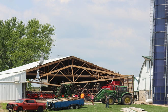
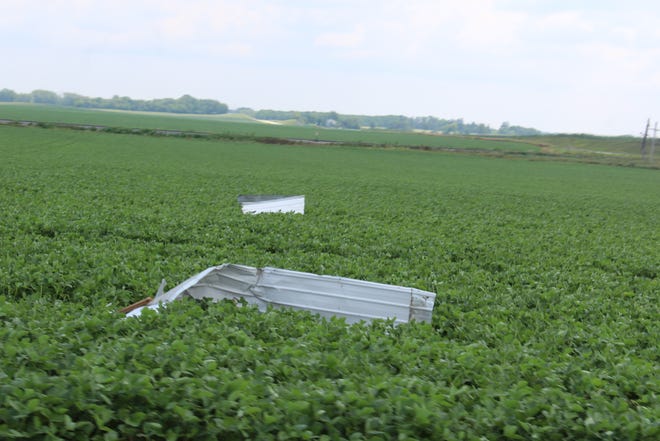
The strong winds also damaged farm pole buildings and storage sheds, flinging twisted sheet metal into nearby farm fields.
Prior to the weather event, many news outlets had forecast the possibility of a derecho-type event. CNN reported that the Midwest including most of Wisconsin was at risk from possible tornadoes, strong storms and hurricane-force winds Wednesday, pointing out that the region was under a level 4 out of 5 threat of severe weather.
"A favorable pattern will exist over Minnesota/Wisconsin toward Lake Michigan today, supporting intense severe thunderstorms and possible derecho development later this afternoon/evening," the Storm Prediction Center reported.
To be called a derecho, severe storms must have winds in excess of 58 mph and cause damage spanning at least 250 miles.
The derecho that hammered Iowa last year destroyed $802 million in corn, soybeans and pastures, with farmers absorbing nearly one-third of the losses.
The derecho's straight-line winds reached 140 mph on Aug. 10, 2020, as it traveled 770 miles across eight states from South Dakota to Ohio.
Before the storm hit, the U.S. Department of Agriculture had been expecting a record national corn crop this year of 15.3 billion bushels harvested from about 84 million acres. Iowa was to provide about 18% of that production. Iowa’s crop was valued at about $9.81 billion in 2019.
Colleen Kottke of the Wisconsin State Farmer and the Milwaukee Journal Sentinel contributed to this report